Llandrindod Wells: Quarries
Located between the British Legion Club and the hospital (now at the side of Trefonen Estate) marked by 2 tall stone columns rising from the track bed of a tramway line in a patch of scrub land. Consists of 3 quarries known as the Llanfawr Quarries, which have been designated a site of geological interest by the Nature Conservancy. The quarry with rich fossil beds was allowed to become flooded so long as geologists could still access the fossils which are mainly of creatures from tropical seas (mostly trilobites). The date when quarrying began is unknown, but the quarries were on Middleton land, with part of the estate mortgaged and ultimately under the control of the Midland Bank. It is believed that there were quarries operated by the Middleton family on the Llanfawr site during the second half of the 19th century, but the quarry leases go back only as far as 1904. The quarry was used by Thomas Lant, a stone mason in the Elan Valley for the granite to help provide stone for the dams and some of the stone was used for building local houses. Lant bought the quarries from the Middleton Evans estate in 1919. On sinking a shaft in the middle working he struck an underground stream and the result was the formation of a pool which is 35 feet deep. This was later stocked with chubb. In 1939 a fire in the plant house caused the closure of the quarries which have never been reopened. Latterly the Llanfawr Quarries came into the ownership of Mr William Knill of Cefnllys Lane.
[Newspaper Cutting at County Archives (un-named and undated)]
[Newspaper Cutting at County Archives (un-named and undated)]
Llandrindod Wells: Stone Circle
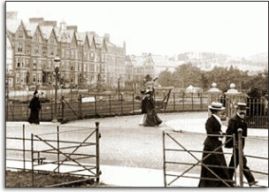
Situated on the site of Temple Gardens, the stones gave their name to Temple Street, Temple Bridge (Five Ways), Temple Fields (house now part of The Metropole Hotel). Six large stones lie in the hedgerows opposite the Manor Home, Lindens Walk. They were possibly once arranged in a circular form. Their origin is contentious: they were placed in a circle c1890s by Council Officials (see OS 1st Ed. Map of 1887), but the name Temple was in usage at least as early as 1816 (Turnpike Trust minutes); "Temple" might be a literal translation for the name of the stream that "Temple Bridge" crossed - that is "Arlais" [the temple or brow of the head]; but this is difficult to prove as there are other spellings of the name. Nor does this explain the existence of the stones. It is possible therefore that these stones were once part of a stone circle (the site was until the 1850s on open common on a site similar in topography to other stone circles and cairns); locals remember the water carriers, who transported water from the springs in the Rock Park to the station and hotels in town, tying their donkeys to these stones - which they moved to make more usable tethering posts. This site was the subject of much research and speculation after the planning of the public gardens c1990-92.
[AE; Enquiry File 21/4L; Trans. Woolhope 1867 p39; Llandrindod guide books]
[AE; Enquiry File 21/4L; Trans. Woolhope 1867 p39; Llandrindod guide books]
Llandyfalle: Church of St. Matthew
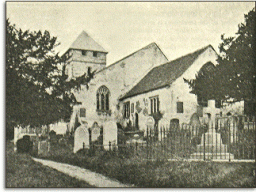
Medieval church once dedicated to St Maelog. The site may have an early medieval origin but the oldest parts of the present building date from around 1300. It was at one time in the possession of Clifford Priory over the border in Herefordshire. The west wall and some windows date from around 1300 while other windows and masonry date from 13th/14th centuries. The upper part of the tower dates from the 17th century. Restoration before the Great War seems to have been more sensitively done than at other churches in the county.
[Haslam; CPAT Historic churches werbsite]
[Haslam; CPAT Historic churches werbsite]
