Llansantffraid Cwmdeuddwr: Nantgwyllt house
Much of the lands of the Elan valley had belonged to the abbey of Strata Florida [Ystrad Fflur] which enjoyed the revenues from the farms and had two granges here. The Nantgwyllt estate came into being by a gradual conglomeration of lands after the dissolution of the monasteries. The final Nantgwyllt House (right) was probably built in the late 18th century and was the centre of a large estate. It was occupied briefly by the poet Shelley and his new wife in 1811, who tried but failed to acquire the house. The house and the small hamlet of Nantgwyllt were demolished before the valley was flooded at the end of the 19th century.
For more on the great Elan valley dams project click here.
[RT; CAO R/D/LEW; The Vale of Nantgwyllt]
For more on the great Elan valley dams project click here.
[RT; CAO R/D/LEW; The Vale of Nantgwyllt]
Llansantffraid-ym-Mechain: Foel Camp
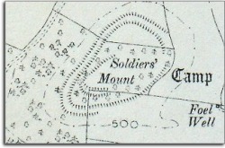
Also known as Soldier's Mount this is a hilltop defended settlement of probable Iron Age date covering just under 2 acres. The ground is steep on three sides with the strongest surviving defences and entrance on the more approachable eastern end of the roughly triangular site.
The image to the left shows the hillfort on an Ordnance Survey map of around 1900
[MC 4]
The image to the left shows the hillfort on an Ordnance Survey map of around 1900
[MC 4]
Llanwddyn
The old village of Llanwddyn
Small upland community in the valley of the river Efyrnwy. In the 1880s a project to dam the valley to provide clean water for the city of Liverpool by pipeline was approved and the first large stone-built dam in Britain constructed. The area behind the dam became a great reservoir. Unfortunately this area included the village of Llanwyddyn. The parish church, two chapels, three inns, ten farmhouses, and 37 houses were all to be lost under the rising waters. A new settlement was built lower down the valley by the Liverpool Corporation before the flooding for the people who lost their homes.
The buildings of the old village were knocked down after the people moved out, and even the remains of the dead were removed from the churchyard and reburied next to the new church.
See the entry for Lake Vyrnwy (Llyn Efyrnwy) for more on this great Victorian engineering project.
The buildings of the old village were knocked down after the people moved out, and even the remains of the dead were removed from the churchyard and reburied next to the new church.
See the entry for Lake Vyrnwy (Llyn Efyrnwy) for more on this great Victorian engineering project.
Llanwnnog: Church of St Gwynnog
It is thought the church could have been founded in the 6th century as a daughter church of Llandinam. Certainly the dedication to St Gwynnog and the previously curvilinear churchyard suggest an early medieval origin. A church is not recorded earlier than 1254 however. The east window is of 15th century date and it may be that some of the fabric is of an earlier (possibly 13th century) date. The church was restored in 1862/3 in Perpendicular style, and it is possible that the rebuilding of parts of the south and north walls were done then. The west wall was rebuilt in 1982 using old material. The church contains a fine 15thC or 16thC rood screen and loft.
[Haslam; Historic Churches Survey]
[Haslam; Historic Churches Survey]
Llanwrthwl: Carn Gafallt
Nennius, writing around 800 AD, records a cairn on the mountain slopes with a large stone on the top bearing the imprint of the foot of Arthur’s hound Cabal. Nennius claims this magical occurrence took place during Arthur’s hunt of the boar Troynt. This is almost certainly the hunt of Twrch Trwyth which is described in the Culhwch and Olwen tale from The Mabinogion. The hill in Llanwrthwl parish which has the name Carn (or Corn) Gallt has many bronze age cairns on it’s slopes and terraces.
Llanwrthwl: Church of St Gwrthwl
The dedication to and early saint and the general shape of the enclosure suggest an early foundation but there is nothing in the site to confirm this. A church here is recorded in 1291 but the simple two cell church which stood here was completely rebuilt in 1875. A massive monolith 1.8 metres high stands next to the church. This could be a bronze age standing stone. It may represent the first stage in a continuous ritual usage of the site.
[B; Haslam; Historic churches survey]
[B; Haslam; Historic churches survey]
Llanwrtyd: Church of St David (Old Llanwrtyd)
St David’s is situated upstream from the Llanwrtyd Wells on a terrace of the River Irfon. The isolated position and partly curvilinear churchyard enclosure may well indicate an early medieval origin for the foundation. The church here was the original parish church for the parish of Llanwrtyd but does not appear in written records before the 13th century. The present structure is the result of major restoration in 1862. The nave may originally have been 14th century with 16th century extensions and windows. Further restoration in 1969 revealed the rood loft stairs.
William Williams Pantycelyn, the famous hymn writer and later Methodist, was the curate here in 1740-42.
[B; Haslam; Historic churches survey]
William Williams Pantycelyn, the famous hymn writer and later Methodist, was the curate here in 1740-42.
[B; Haslam; Historic churches survey]
Llanwrtyd Wells: From a river crossing to a spa town
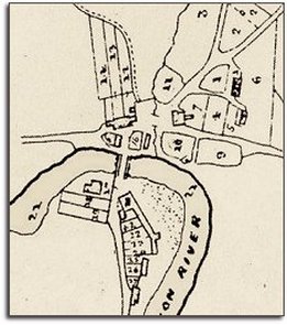
At the time of the 1841 census, the town we now know as Llanwrtyd Wells was a small village of just 27 people called Pontrhydyfferau which had grown - up as its name suggests - at a crossing place on the river Irfon popular with drovers. (The tithe map right shows Pontrhydyfferau in 1845). Three of the inhabitants were working as lead miners in local mines. The coming of the railway and the successful exploitation of mineral waters at nearby spas, encouraged a similar development here, and a change of name to Llanwrtyd Wells. Connections and the proximity to South Wales encouraged the growth of popularity of the spa with more working class visitors from the industrial areas of that region.
Llanwrtyd Wells: Taking the waters
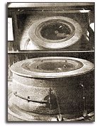
The main sources of medicinal mineral waters in the spa were the Dolecoed and Victoria springs. Another was found at Henfron in 1922, well after the Victorian heyday of the spa. The most famous of the local springs was Ffynon Drewllyd or the 'Stinking Well' at Dolecoed. This is close to the River Irfon, and it has the highest sulphur content of any natural source in Britain. The water here was never pumped but came out naturally at a rate of about 4,500 gallons a day. The source of the water was sealed in Victorian times in a massive round marble pedestal which was decorated with mosaic stones. (See photo) This was to prevent the loss of the natural gases produced in the well which added to the goodness of the water. There was a thick glass top to the tank and visitors could see the gas bubbling through the water in an angled mirror placed above the well. The waters at Dolecoed were piped into baths within the hotel.
The Dolecoed Pump Room also offered water from the Chalybeate Spring which was water containing iron salts.
The Dolecoed Pump Room also offered water from the Chalybeate Spring which was water containing iron salts.
Llanyre: Castell Collen
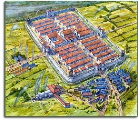
Reconstruction by Rob Davies
A roman auxiliary fort built on a terrace of the river Ithon. It was first constructed around 75-78 AD of timber enclosing a garrison of about 4½ acres. It may have been abandoned for a while and then re-occupied in the late-second century with a reduced size making a more square outline of about 3 acres with stone ramparts replacing the early timber ones. An end date for the occupation is difficult to confirm but the fort may have fallen out of use before the fourth century. Later survey work has revealed a civil settlement or vicus outside the walls with evidence of metalworking.
Stone from the site - including inscribed stones - have been found re-used in Llanbadarn Fawr church at Crossgates and in the fabric of Capel Maelog.
Visit the Radnorshire Museum to see some of the finds from the excavation of the site by Leslie Alcock in the mid-1950s.
Click here to see an aerial photograph of the site today on the Gathering the Jewels website.
[RT; Webster; Burnham]
